Copyright © 2002 text - Joseph Mack.
Copyright © 2002 images - Steven D. Carson. You may link to any photos here. Any other use requires consent from the copyright owner. Most images are thumbnail links to a larger image.
Copyright © 2002 Images linked here include the url of the linked website, where the copyright information of the owners can be found.
initial publication Aug 2002
Table of Contents
- 1. Pre-Introduction
- 2. Introduction
- 3. Preparation for Trip
- 4. About Colorado and the Colorado-Utah Plateau
- 5. Day 0: Arriving in Colorado
- 5.1. Arriving in Eagle
- 5.2. The Colorado Fires
- 6. Day 1, getting some altitude
- 7. Day 2, acclimating by wandering around
- 8. Day 3: moving to camp 2
- 9. Day 4 - heading for the pass
- 9.1. At the Pass
- 9.2. Abandonned Mine
- 9.3. Mountain of the Holy Cross
- 9.4. Heading Back
- 10. Day 5: from Camp II back to Camp I
- 11. Day 6: walking out
- 12. Day 7: Flying home
Figure 1. Holy Cross Panorama
|
Cross Creek from the windy pass at 11,800'. I sat on the other side of the red/brown rock in the foreground for some relief.
The mine mentioned in the text is on the right hand slope of the mountain in the distance at about 40% across the image (at the discontinuity of shading caused by merging photos).
Holy Cross peak (14,006') is in mid distance (60% across image). The "Cross" is on the other side of the ridgeline. The two ridgelines on the left and the right of the image, are approximately parallel and facing the direction of the center of the photo. In this panorama, the ridgelines appear to run across the image.
One of the lakes Steve hoped to get to is the white patch on the left (the lake is frozen over).
This is a trip report targetted to members of the Sydney University Bushwalking Club (SUBW), Sydney, Australia. I've explained some references which may be unfamiliar to people outside the club and I've explained some references which may be unfamiliar to people who have not been to USA. Other than that, this is just a story about a 6 day hiking trip in Colorado. Steve also has a write-up for the trip (and in .doc format ).
 | Note |
|---|---|
This report uses american units; lbs, miles, feet (') and deg Fahrenheit. These units are used only in USA, Myanmar (Burma) and Liberia. | |
The US has convinced the world to use feet/miles for altitude/distances for commercial airliners. Presumably it's safer to teach the rest of the world american units, than to teach metric units to americans. The american units are confusing even to americans, who turned the Mars Climate Orbiter into a Mars lander. A T-shirt celebrating the Mars landing had "Mars: hit the planet and win a prize. Remember 1 mile = 1.6km".
Conversion tables
- 1kg = 2.2lb
- 1mile = 1.6km
- 12,000' = 3660m
-
temperature
F C 68 20 32 0
For dates of metrication, see Metric usage in other countries. In the section on Metrication of Australia, you'll find that the government choose a conversion plan suited to Australia's non-technical populace. They realised that it would be difficult to explain the reasons for metrication to these people and the govt chose instead to first convert bread and circus events, like horse racing. Apparently New Zealand had no such difficulties. We should ask NZ about their education system. Fortunately technically sophisticated countries had already paved the way for us (e.g.Rwanda in 1910).
This hike was with a friend, Steve, who I post-doc'ed with at Yale in the late '70's. We haven't seen each other since then, but we've kept track through xmas cards and more recently by e-mail. Steve spent some of his early years in Eagle Colorado, and returns once or twice a year for R&R. My recent month long return trips to Australia each december are for similar reasons.
Steve has invited me on his trips before, but other things, like establishing a career, seemed more important at the time. After my last trip to Australia, I realised I should take Steve up on his offer, before it was too late and the arthritis (and other things) stopped me. Like all trips in USA, where few people live near a wilderness, this is an epic, requiring multiple plane connections, taking all your food, and ordering maps over the internet. There being nowhere local with similar conditions (altitude) that I could train or test myself, I would be doing the trip cold. With little experience in cold and altitude on my part, this trip was possible only because Steve understood the conditions in Colorado, the altitude, animals, snow, weather... Steve would drive 9hrs from Omaha, NE, where he's an academic at the Medical School, picking me up at Denver airport. We'd drive another 3hrs spending the night in Eagle CO, the town of Steve's maternal family. The next morning, we would drive over a 10,000' pass to reach the trailhead.
To help me doing a trip cold, Steve sent his hiking gear spreadsheet, which records the number of times he's taken each item, whether he used it and whether he still takes it. My approach it to reach into my large box of hiking gear and take anything that looks useful. I'd never seen anything so organised. My approach works when you're going on frequent short trips, when you remember what you need and when leaving something behind has few repercussions. When going to a place you haven't been for a year or two and when the consequences of leaving somthing behind are large, then this is the only way to do it and have fun when you get there.
Steve warned me to bring lots of sunblock - my skin would blister without it, that it would be like an oven during the day and near or below freezing at night. (At 4000m, only 60% of the UV is being filtered out - from EWP adventure guides .) He warned me that the effects of altitude were cruel at our age and it would take most or all of the trip to acclimate. (On my return, from the internet, I found that it takes most people several weeks to acclimate.)
The volleys that I've been bringing back from Sydney for the last 3yrs give me blisters easily. I've never needed to break in volleys before, but this process takes several weeks now. Since I hadn't done any long trips (cold, at altitude or otherwise) for 20yrs, I increased the load for my standard lunchtime walk from 30lb to 45lb, when even my broken-in volleys gave me blisters again. Steve's list includes insoles, something I don't think about, but important enough to Steve for a successful trip, that they get an entry. I bought every kind of insole at the local hiking store and the local athletic footwear store and tried them all out a day at a time, till I found one that fixed the problem. The ones that worked were smooth and shiney, letting my sox slip over them. At Steve's suggestion I switched from cotton soxs to smooth polypropylene sox, clearing up 3yrs of blister problems in one go.
My shoulders, back and knees were close to their limit, but as it turns out that on the trip they were managed by advil. When I was younger a little overload would just slow me down or make me sore, but nowadays, if I push my body, I risk something going out and not being able to walk a step. I'm in reasonable condition otherwise - each visit to Sydney I do Govett's to Govett's (via Junction Rock, Blue Gum, Perry's and the cliff walk) in about 8hrs and still be good enough shape to enjoy a feed at the Blackheath pastry shop. I don't get aerobic conditioning, not being able to run anymore with a bad knee, and for exercise, have to rely on a lunchtime walk on flat ground, with a few sandbags in my pack. A few steep hills would help, but I live in North Carolina on the coastal flat (and sandy) flood plane.
Colorado is in the uplifted western 1/3 of USA, with valley floors at 5-8,000'. From maps of the world, this region appears to be the largest elevated area in the world. Here olympic athletes train, where they can sleep high (at 10,000') and drive to a nearby town where they can train low (a few 1000'). The surface features of this elevated area are varied. The western end (Nevada), is basin and range block faulting. The eastern end of the plateau meets the jagged peaks of randomly tilted metamorphic Rockies, which rise to 14,000'+. In the north, the large flat valleys and salt lakes of Utah are surrounded by sedimentary plateaux interrupted by the occassional metamorphosed mountain or inactive volcano. In the south are the mountains of New Mexico that Robert Oppenheimer loved, and where he moved the WWII atom bomb project (Los Alamos).
In the middle is the Colorado-Utah plateau. This is a sedimentary basin (like Sydney's) many 100's miles in diameter with near horizontal strata. The basin is best known for where it has been cut deeply and rapidly by the Colorado R., forming the Grand Canyon, a sight so grand, that I recommend you see or hike through at least once in your life.
The whole elevated area is arid, and cold in winter. The area is desert being in the lee of the prevailing winds from the west which pass over the (Californian) Sierras. As you cross the Sierras from the west to the east, green forests turn into Nevada desert in a matter of miles. You can stand on the ridge line or at a pass and look on green vegetated valleys to the west and brown arid valleys to the east. As the air crosses the 500 miles of the Colorado-Utah plateau it picks up moisture again (although no-one has told me from where, it's hard to imagine it's from the desert below) and rainfall increases gradually as you reach the Rockies. Then as you cross to the eastern, lee side of the Rockies, the rainfall drops again. Although desert or near desert, there is plenty of snow in winter. Being on the western side of the continental divide (the Rockies), the water from the plateau mostly flows to the Colorado R. (with some to the Rio Grande). The water which falls on the lee (eastern) side of the Rockies flows to the Mississippi R. The main primary industry of the plateau area is cattle ranging and more recently skiing and people like Steve and I (tourists). There is not enough water to grow food commercially in most areas, although the Native Americans lived on corn grown in the few watered valleys, using precise observations of the winter solstice to plant their crops. With only 120-130 frost free days and because of the altitude, there is little time to spare [1] . If you plant too late, you have to harvest before maturity, too early and you kill the new plants. You can't rely on sticking your finger in the air to to time the planting of crops and the Native Americans relied on astronomy and statistics to optimise their chances of a crop each year. With the arrival of Europeans, a thriving agriculture (potatoes, lettuce, etc) started, but the arrival of refrigerated rail freight allowed California with multiple growing seasons to quickly dominate the markets. With irrigation all things are possible, and Grand Junction (another 125 or so miles west of Eagle) still has a thriving fruit orchard economy.
The are many different surface features of the Colorado-Utah basin such as
-
Grand Canyon from Mather Point (by The Grand Canyon Trust)
and
a shot from Gil T's site
The Grand Canyon is large enough to contain the whole Blue Mts.
- http://www.nps.gov/brca/ppphotos/inbrycea.jpg Bryce
(by NPS, link dead Dec 2003)
These strange multicoloured pillars are caused rain dissolving the limestone which cements the sandstone (from the book by Seymore Simon in the references). Bryce is on the western side of the plateau.
-
http://www.nps.gov/zion/weather/default.htm Zion (by NPS, link dead Dec 2003)
here seen by the weather-cam
Zion is where I found out about aeolean deposition. The Blue Mts are all marine sediments with horizontal deposition and straight horizonal discontinuities between layers. This was how I thought about all sedimentary rocks. In Zion I noticed that within the horizontal layers (1-60' thick) the coloured bands within each strata, instead of being horizontal and straight, were curved and steeply sloped. The pattern repeated continuously for 100's of yards. I was as surprised as if I'd seen a 2 headed person and couldn't think of any explanation till a ranger straightened me out. Zion had originally been sand dunes deposited in air, and the coloured bands within each layer were the curved sides of the sand dunes.
The drive out of Zion involves a mile-long tunnel, thus avoiding a scar on the rock face like on Kings Tableland facing Kedumba Valley, a road that was constructed for no real reason at all. I know the scar is not so bad, now that it has weathered a bit, but back in the 70's it look terrible. Only in america is there enough money to drill a mile-long tunnel to save a cliff-face from an ugly scar.
- http://www.nps.gov/cany/ppphotos/whiterim.jpg the Canyonlands (by NPS, link dead Dec 2003) and more Canyonlands by Moab Internet
-
the "mittens" at the Navajo reservation in Monument Valley
(a link from
Max Bertola's page on Monument Valley).
See also
another photo of the mesas with one of the mittens (by Virtual Guidebooks)
(May 2003, they moved the location of this image -
it was http://www.virtualguidebooks.com/Arizona/Navajoland/BelowMonumentValleyVC.jpg target="_top")
These mesas are often seen in glossy magazine advertisements, where a Jeep has been helicoptered onto the top of one of the mittens.
Both times I've been here it's been bitterly cold with blowing sand. It's hard to imagine living here. The short and violent desert rains cause flash floods which wash away sand, rocks and even boulders. The same rainfall dispersed throughout the year would soak into the soil allowing grass to grow. The distinctive formations are caused by the flash rains and the fierce winds. [2]
- Capital Reef
(by AmericanFocus)
It takes a good part of a day to drive through the area containing these dramatic cliffs. I would love to hike here, but without any knowlege of how to survive in the area, the chances of dying of thirst seemed very high.
- Moab (by Moab Internet), a favourite location for cowboy films.
-
my favourite is the Goosenecks,
a series of sweeping meanders,
cut 1000' into sedimentary rock, where 5miles
of river only progresses 1 linear mile.
The original link to an image by the
by Utah State Park Service is dead (May 2003),
accompanied by a notice that they did so to
enhance the quality of your life, but they won't tell you where it is now
(even the The Wayback machine
can't find it).
In its stead here's an
image of Goosenecks in late afternoon (ie with bad shading),
by internet personality Brad Templeton (link from main page at
The Best of Utah).
Other nice photos of Goosenecks are at Mr Jolley's site
ttp://users.mstar2.net/jolleyb/about_mr_jolley.htm (link dead Jan 2004)
where you can find this image of Goosenecks
http://users.mstar2.net/jolleyb/images/goosenecks.jpg (link dead jan 2004)
(with nice shading).
Another is
from a (link dead Mar 2004, http://psego.tripod.com/travel/san_juan.htm)Sierra club trip down
the San Juan R (with pop-unders) giving this image of
(link dead Mar 2004 http://psego.tripod.com/travel/photos/goosenecks.jpg) Goosenecks.
There are places like the Goosenecks in the Colo, where the river a mile or so downstream of you is only 50-100' through a cliff next to you. The difference is that at the Goosenecks, there are no trees to block the view.
For more photos, see Gil T's photo site
These various surface features rely on the different rate of water flow through similar rock. In some places, like Monument Valley, you are at the bottom of the strata looking up and at other places, like the Grand Canyon, you are at the top of the strata looking down. On leaving Zion or the Grand Canyon, you find yourself on the most unremarkable flat land stretching uninterrupted to the horizon in all directions. You have only the geologists and your memory of looking at the depth of rock cut by the river at the last place you visited, to remind you that you're driving on 6,000' of sedimentary rock, just waiting for a few million years of some future Colorado R. to produce another Grand Canyon. The strata of the basin can be identified from one side to the other, by their colour and order. Apart from a few faults (seen in the Canyonlands, where you can look across a valley and see different strata than the one's you're standing on), the basin is largely undisturbed.
In areas where the rainfall is more regular and less violent, the rivers produced wide flat valleys (at 5-8,000'), surrounded by flat topped mesa (tableland) plateaux. This land could be settled and here cattle ranging started. Because of the low population density still today (few cars), visibility is good (40miles on a normal day). Life was difficult here for the early settlers. Being trapped in winter, you had to be self sufficient, and make do with what you could produce with your own hands. Presumably after Denver became a town, it would have been able to provide supplies to the hinterland (like Eagle 150miles west of Denver), but no horse and wagon could have carried much of a load over the steep dirt roads that crossed the high passes between Eagle and Denver. Oh and if you got sick, you died (the usual fate for most people before antibiotics, but even more so for these people).
Explorers, settlers, wagon trains, railroads, and highways all followed the rivers (this algorithm failed for crossing the Blue Mtns), and by a coincidence of geology and weather, the freeways that now cross Colorado from east to west, go through these first settled wide valleys. The long lasting snow on the mountains surrounding the valleys have become the modern ski resorts, eg Vail, Breckenridge and Aspen, for which Colorado is famous.
Vail was established in the late '50's by Pete Seibert, a US champion skier, who trained in the '30's in Vermont (US NE coast) with instructors who'd fled Austria before the immenent war. Steve thinks that Seibert got his idea for Vail during his training at Camp Hale (somewhere between where we hiked and Leadville, in CO) with the US ski troops for WWII. The foundations of the installation were still visible last time Steve drove that route. The high school girls from the nearby small towns (including Steve's mother) used to go to dances there as part of the USO effort to entertain the soldiers (presumably to the chagrin of the local highschool boys). Pete then served in the military ski units in WWII in Italy and on his return recognised that Vail mountain would provide better skiing than anything in Europe. Vail provides 3000 vertical feet of skiing in all directions, and at 8000' is below the treeline [3] providing shelter from winds (i.e. you're skiing amonsgt trees [4] ). Seibert secretly bought the land telling anyone who asked that he was building a hunting and fishing lodge. Each $10,000 investor was given 4 lifetime lift passes, and for $500 more, they would be given land to build a home [5] .
The development of the Australian ski fields was initiated by by refugees from Europe, who had first come to Australia for the Snowy Scheme: Smiggins by Tony Sponor and Threadbo by people I've forgotten. In Colorado, you don't have to drive 300miles to Koscie to go skiing though - you just pull off the freeway.
These resorts in Colorado have grown up using all the mechanisms of modern capitalism; large loans, good publicity, rich people to serve as the initial clientelle... Now the valleys are filled to the gills with condominiums and holiday resorts, most of which now are far enough from the ski lifts that you drive to them and leave your car in a multistory cement parking lot (c.f. the Sydney U. ski hut at Thredbo where you can walk to the ski lift). Presumably most of this land in the valleys was bought for a song over the last 50yrs by big corporations, from the original settlers. Some of them had little idea what was going to happen to their quiet valleys. Others knew what was happening, took the money and moved to a warm retirement. Some of the land (e.g. Aspen) was owned through mining claims long since run dry, and bought cheaply or by payment of back taxes. It didn't hurt that the Federal and State Govts lent a hand, turning Govt owned National Forests [6] into the ski slopes. Don't think for a minute that the developers got a free ride here - they would have given back a hefty chunk in campaign contributions to cover this one.
With the condos lying fallow every summer for the last 50yrs, the owners had plenty of incentive to find things for people to do, holding conferences for the citizens of the highly populated baking-hot east coast, hang gliding lessons (you catch the ski lift up and glide miles back to the parking lot), and lots of trails. They've did such a good job of it that that summer accomodation rates have risen from half the winter rates to being on par.
The part of Eagle that Steve knew when he was a kid, a 4 block section in the centre of town, now looks like a Disneyland mock-up, surrounded by new expensive homes for the idle rich, who have moved in from elsewhere to retire. The old stores have been redone for tourists like Steve and I, using the original structures [7] . We bought our fishing licenses there and had a couple of meals well matched to hungry hikers, presumably at what were the Eagle equivalent of the pastry shops at Blackheath or Richmond.
The alternative to tourists, a Colorado without tourist dollars, would leave Colorado like W. Virginia, a region stricken by lack of jobs and poor education, with no prospects on leaving high school, except marrying and/or joining the military. Even for a tree hugger like myself, instances like this show that it's not always clear what the best use of public land should be. I saw how beautiful the mountains were and remarked that wished I could find some way to live there. Steve replied that a lot of other people thought so too and that's why people like him had decided not to live there anymore.
While the Colorado rockies are packed with hikers enjoying the wilderness, the Colorado-Utah plateau with it's dramatic cliff walls is much less a hikers paradise. I don't know why but these are possibilities
- all parts are remote and being in desert, there are no nearby population centers. This at least has helped preserve its wilderness character
- Few people have accumulated experience of how to hike safely there or done much route finding for good trips.
-
It's a forbidding place. 500 people have died in the Grand Canyon alone,
most of dehydration
[8]
. You cannot prepare yourself for travel in these areas
when living 1000 miles away in a humid, forested area.
While you have to be told that hiking through the Grand Canyon is problematic, it doesn't look that bad. The Colorado River is thundering 1000' below you and there are roads another couple of thousand feet above you. The fact that you can't get to them easily if you need to isn't obvious. However no-one needs to tell you that Capital Reef is a place where a poor decision will mean you won't be coming back and your body won't be found. There is no water and no roads and it's either blazing hot or bitterly cold. I'd give a person who walked off unprepared by mistake from a car there, a day at most.
- As Mole points out, the rock in the Grand Canyon is rotten
(so is Bryce). Other places, like Capital Reef, the cliffs look really solid.
Around Sydney, breaks in the clifflines are negotiable, but the Grand Canyon has no vegetation to grab and the cliff comes away in your hands. Because of this, there are only 3 routes through the cliffline, from the 50 mile long south rim of the canyon. Anyone going in from the south rim does basically the same walk. The scenery is dramatic, but there's really only one hike for people with no desert preparedness.
Interestingly because of isostatic uplift, many of the island tablelands of the Grand Canyon are joined to the main plateau by broken necks, with the island uplifted by 10-60' compared to the plateau. This is particularly obvious when the neck still exists, is narrow and is breaking up. You can visually match up the strata at both ends of the neck. Later the neck crumbles to the valley floor leaving an isolated mesa and you can't match the strata by eye anymore.
On seeing these discontinuities, I thought of Narrowneck at Katoombah and was absolutely sure that I'd seen a similar break in the neck out at the end near a large scrubby sloping area with no trees. I could even remember a vertical break in the road at this spot. I was amazed that no-one had recognised it. There I was in USA, with this great hypothesis and not able to check it. I discussed this with Mole (we were both in the USA then) and he couldn't identify a break in Narrowneck. When he returned, he reassured me that there was no break. I was disappointed that even Mole couldn't find the obvious break, so waited 20yrs before I returned to check it myself. I've checked personally now and indeed there is no break in Narrowneck's neck. It's the longest period I've had between hypothesis and answer for any of the questions I've asked in my life.
- Most of the individual sites mentioned above, while each are extensive, are a good day's travel from each other.
- Bryce is only a small area (maybe 2 miles long). There is a trail around the bottom of the spires, but the little valleys off the trail are a fractal navigation nightmare that I didn't want to get into. As well you aren't allowed to camp there. To visit Bryce you have to drive a long way and return in the same day, so you can't spend much time there. (It's also at high altitude, bitterly cold and windy. It would be hard to camp there, even if you were allowed to.)
Zion, although dramatic, is only a single cliffline facing a plain. On the top of the cliffline is the plateau. You can hike extensively on the plateau, but it's just flat, dry and with no vegetation; you could be in any flat, dry place. You camp along a river coming out of the cliffs making the immediate valley an oasis in the desert. There is only an easy walk up a creek to the plateau to look at the aeolean deposition patterns in the cliff. Zion is mainly for looking at the cliffs from the campground. (It still is beautiful.)
When I was at Zion, a TV crew was filming a rockclimber on the first solo ascent of a needle (I think it was ABC's wide world of sports). He was belayed but I didn't know how it worked - there was no-one else with him. A helicopter hovered above and I watched from the camera crew location opposite the climber across a canyon. My heart was in my mouth as I watched him climbing a slighlty overhung smooth wall. He took what I thought was a rather long fall, and managed to get back to the rock face and resume climbing apparently unscathed. I couldn't handle watching any more and left. He was risking life and limb just to add a thrill to the meaningless lives of the couch potatoes back in the big cities. I was glad to hear later later that he made it safely to the top.
For about the last 30yrs, the amount of the world's oil supply has been pegged at 30yrs [9] . It seems that no-one really knows how much oil we have, but everyone agrees we don't have much of it. However the amount of coal available is in the order of 300yrs by everyone's estimate. There's just absolutely tons of the stuff - we have nothing to worry about energy wise, even if we do run out of oil tomorrow. We just have to figure out how to use all that coal without producing a run-away greenhouse effect and poisoning the earth with the heavy metals (e.g. Hg) vented to the atmosphere when burning coal. However with scientists still squabbling about the effects of atmospheris CO2 on global warming, the only prudent thing to do is to give them a $M or so for more scientific research (they'll be grateful and it will keep them occupied) and meanwhile, and use the coal as fast as we can. At least that's how the politicians are thinking over here. Half of this 300yrs of coal is in the Colorado-Utah basin. The other half is (you guessed it) under the Sydney Basin.
All those places we go bushwalking are just opportunities for Sydney to become the middle east of coal, or the Chile (where the money went to US corporations), or the West Virginia (same), or the Louisiana (where the money went to corrupt politicians), or the Orinoco R. (where there are large pollution problems e.g. see the Inventory of Confict and Environment). There's so many wonderful opportunities for the Australian economy here, I don't know which to look at first. We could decide to become the Texas of coal, using the money to fund hospitals and academic institutions, but none of the australian polys want to do this. You do know that coal leases have been let under the Avon, Cordeaux and Cataract dams and out the other side, don't you? There's going to be nothing solid under the water of these dams anymore (for more info see the articles by Keith Muir of the Colong Foundation on mining in the Sydney water catchment area). Another coal mining technique (used in W. Virginia) is mountain topping - the mountain top is removed, thrown in the local rivers (the mountain tops are all natural afterall), the coal is removed and then the coal company leaves town, with the valleys improved with natural rubble dams (e.g. article in the Washington Post). The only benefit to W. Virginnia is the (low) salaries and benefits given to the mine workers. For the industry view on the matter see The Facts on Mining. For a view of what it looks like to try to get out of this situation, for a politically unsophisticated populace, whose economy is based on extractives, see an article on the possible future of W. Virginia (http://www.lincolnjournal.com/miller424.shtml link dead Dec 2003). With weak unions, if the workers don't like the conditions, the company closes the mine (one of many they own), till the workers, who can't move, can't pay their bills anymore and have to come back. (There have been several multi-year strikes in W.Va. I can only imagine the disruption this must cause to people trying to raise a family.)
Eagle, where we stayed at 6,600' the first night, is on the eastern edge of the Colorado-Utah Plateau. The cliff faces instead of being flat with cleavage planes like in Sydney, are either rows of columns or pillars (common in the Canyonlands) looking like totem poles, or rows of totem poles waiting to be sculpted out. The points on the ends of the cliffs all have miniature Three Sisters (at Katoombah) type rock formations (image from Ahmad's website, I couldn't find one on any links from the SUBW site). The sedimentary formations around Eagle look more like Bryce, several 100 miles to the west.
A few miles to the east of Eagle, the rocks change to the convoluted metamorphosed Rockies. This is where we went to hike. There on the hike, I saw bands of rock folded into an "S" that fitted into a square box 1' across.
The real problem hiking would turn out not to be my joints, but the altitude. My last trip at altitude was about 20yrs ago. Back then, as long as I spent a night at 8,000' I was OK to go higher the next day. The alternative to spending a night at 8,000' was terrible headaches. On my last trip at altitude, I scrambled to the top of Mt Ritter at 14,000'+, the highest peak in the central Sierras. I was OK till 14,000', when I was only a few 100' from the top on a smoothly convex pile of broken rock. From there, at sea level, attaining the peak would have been trivial, but here I needed 3 breaths for every step. It took forever to finish the final walk to the top. Once at the top, I was rewarded with a view like out of a helicopter. For 270 degrees, I looked down 5000' along a 45deg slope, to our campsite of the night before at 8000'+. The other 90deg of the view, was the ridge of the Sierras behind us. Other than being incapacitated from lack of oxygen, there was no particular distress from the altitude; you breathed hard to just stand up, but otherwise things seemed pretty normal. Once I got down below 14,000', I was back to operating as if I was at sea level level again. I was hoping it would be the same this time, but with 20yrs of accumulated decrepitude, I knew this would be a new toss of the dice.
Steve picked me up at Denver airport. I hadn't seen Steve in 25yrs. The only changes I noticed was the amount of our hair. Mine had been down to between my shoulder blades, but now a standard business haircut. His had been a standard business haircut and now his treeline had descended to just above his ears.
Denver airport was at 5,000' (the "mile high" airport). To reassure myself, I looked for signs of altitude as we drove out of Denver into the mountains, but sitting in Steve's car I was unlikely to find any and didn't. Last time I was in Denver, 25yrs ago, the air was clear, but now with all the new arrivals, the air pollution in Denver reduces the visibility to only a few miles, all due to car exhaust and the low rainfall. It looked just like LA to me. The mountains a few miles away were seen only in silhouette. Here's the mountains just north of Denver (the "front range") on a clear day. The photo is looking west from the plains and is a link from the Denver information bureau
We drove west along the freeway passing through the Eisenhower tunnel at 11,112'. The tunnel bypasses the many switchbacks needed to cross the the Loveland pass at 11,992', still used by trucks carrying hazardous materials. It's always a little strange to go through a tunnel or over a pass several 1000' higher than Koscie (Australia's highest mountain).
At the end of the Au rush in California, when Au was no longer workable using the resources of individuals, prospectors left for other likely spots, like Bathurst and Colorado. The whole of Colorado was combed for minerals by enterprising individuals, who had only a mule for help and who lived for months by themselves. Due to the absence of vegetation, mine entrances can still be seen as you drive through the state. The miners dumped the yellow tailings at the entrance to the mine, which would slide down the 30 deg sloping hillside, producing a yellow streak for several 100' on the grey rocky moutainside. With these yellow streaks visible every couple of miles, I realised that the state had been thoroughly explored by 150yrs ago. The volume of rock outside each mine was small, possibly several man months of work, and I couldn't imagine anyone making a living from such small mines even if Au had been found. If Au had not been found I couldn't imagine why they'd persisted.
Initially people were after Au, but this ran out quickly, and then in turn, Ag, Pb, Cu and Sn were discovered, and shortly thereafter Zn (Gilman mine) and Mb (Climax mine). A hundred years later the price of Au had risen enough that it was economical to rework the tailings of the big mines. (On the other end of the scale, Kennecott Copper in Utah operates the largest open pit mine in the world, 2.5m across and 3/4mile deep which is open to the public for viewing 365days a year.)
Arriving in Eagle at 6,600', 150miles west of Denver, the air was clear and the sky a deep blue. However just walking around required breathing as if I was climbing a steady 30deg slope. For heaven's sake I thought, 6,600' is nothing: the air pressure in a jet airliner (equiv to 8,000') is lower than at Eagle. I felt quite light headed, like I'd had a beer on an empty stomach. Expecting a splitting headache the next morning, I passed on the beer with dinner, thinking it would put me at an effective altitude of 12,000'. I hoped by not challenging the gods of altitude headaches, they wouldn't notice my arrival.
One of the first things you notice in Colorado, is the simultaneous aridity and large amounts of water in the many rivers. The humidity was 10-14% by my personal portable sling psychrometer. (the humidity was 5% at Blue Gum on Xmas day 2001 during the bushfires). The soil was dry with mostly sagebrush and some cedars and pinion pine. Mostly the dirt was just dirt, there being no other ground cover. Right next to the bare dirt could be a rushing clear river with nothing growing in the river - all the rocks were clean. Large amounts of water rush and tumble through the rivers, any one of which has more water than all of the rivers around Sydney combined.
The Colorado fires started the day we arrived. These fires have been the biggest in Colorado history, the result of low rainfall and idle rich people building houses in previously unpopulated forested areas. The first fire was at the next stop west on the freeway, at Glenwood Springs. The fire had closed the freeway, and if we hadn't already planned to spend the night in Eagle, we would have anyhow. There wasn't a spare room in any of the motels and the town was filled with stuck tourists. Later that night when ordering dinner in the old part of Eagle, the waitress asked if we were stuck in town for the night. I was somewhat miffed. I was wearing my volleys and King Gees, did I look like I was here for a hike or what? Steve had grown up in this town. He gave the waitress a friendly smile and told her we were in town to do some fishing and pointed out to me that a number of tourists were stuck in the town that night.
The fire at Glenwood Springs started from a coal mine fire, burning since 1912. Coal mine fires seem to be an accepted part of US, and no-one seems terribly concerned about them. One town Centralia in Pennsylvannia (see news report by the Tribune Review and an essay) had to be moved when the warm ground under it collapsed as the coal mine burned out. They'd tried to put out the Glenwood Springs coal mine fire, but gave up when they found that this produced explosive gases [10] .
After dinner, we watched the houses 10miles away burning on TV, and the residents being evacuated. I called Mardee (my S.O. from USA, who's been down Claustral) to let her know that we were near the fire, but wouldn't be affected by it. Fires started simultanously in 4 places that day although only the Glenwood Springs fire had any extent at this stage. The other fires, particularly the Hayman fire (the large fire of the summer), 150miles away, at the other end of the state, flared up the next day after we walked into the wilderness. While we were away, the papers had 2 days of front page photos of hills red with flame in Colorado. Fortunately Mardee worked with a person from Colorado, who knew where I was and that I was in no danger. When I returned to work a week later, I was greeted with "You go to Australia, there's fires, you go to Colorado, there's fires. What's the story?"
The fires burnt for another month consuming 1000sq miles of forest and featured prominently in the news each day. Unlike around Sydney, large fires in Colorado occur only every 300years or so (all the fires for the last 2000yrs have been dated, presumably through sediments) and the forest takes 50-80yrs to recover. In Sydney, trees survive a fire and 10yrs later, the bush is all green again. In Colorado, the same fire kills all trees and 10yrs later only a few saplings are poking through the ashes of a still burnt-out landscape. A scorched pine tree looks like it has melted - the needles give out tar which clumps the needles together in a big glob. In the Blue Mts, people expect to see the bush recover from a fire in their lifetime. In Colorado, people build multimillion$ wood frame houses out in the woods, with a wonderful view of the forest. The usefull lifetime of these houses 30-50yrs [11] . If a fire comes through which doesn't destroy their house, but burns the forest, they aren't going to see forest again in the lifetime of their wonderful retirement mansion. They're surrounded by moonscape, probably half their neighbour's houses are gone and their multimillion$ retirement house is worth almost $0 for resale. These people are aggrieved by their sudden, undeserved and unexpected misfortune and wonder why something wasn't done to prevent it. Fingers are pointed at firefighters.
The people into "proper resource management" say "I told you so, this would never have happened if you'd allowed controlled logging, according to the well known principles of optimised resource management, by my lumber company" while the tree huggers (who presumably are into resource miss-management) say "until people started building houses here, this forest burned only 8 times in the last 2000yrs and did just fine without any logging at all, thank you". The US president, in August stood in front of burnt-out forest in Oregon, and announced his plan for preventing forest fires - cut down the forest. He is allowing lumber companies to cut down the forest in a time of depressed lumber prices when mills in both Canada and USA are shutting down. Instead of forest fires we'll have prairie fires.
Figure 2. George Bush II saves Oregon's Forests from fire (Aug 2002).
 |
Cartoon (C) 2002 by Mike Peters, the author of the comic strip "Mother Goose and Grimm". The original link (http://www.grimmy.com/images/pol2002/MP082902.gif) is dead (Jun 2004).
The next morning, in Eagle, I awoke with a clear head. The gods of altitude headaches had not found me and I optimistically hoped for few altitude problems.
The trailhead was about 2hrs away along a dirt road, over a pass at 10,000'. We quickly left the dry sagebrush valley and entered trees at the cooler and wetter elevation. The road had some tourists, one completely out of place in a Lincoln Contenental, who to avoid the closed freeway at Glenwood Springs. was doing the equivelent of Richmond to Bathurst via Oberon.
Upto about 8,000', many of the creeks had beaver dams. Beavers have only recently returned to the area, having been trapped, mostly by leg-hold devices, for their pelts. A river with a beaver dam every mile or so will delay the spring run-off into the whole summer, keeping the rivers downstream flowing all year. The beaver ponds allow plants and fish to grow, and provide food for birds and animals and nesting spots for birds. Above 8,000' there were no more beaver dams. Beavers can go to 10,000' here, but haven't repopulated higher altitudes yet. Presumably beavers will stop at high enough altitude, where the ponds behind their dams freeze solid in winter. (for more info about beavers: Beavers: Wetlands and Wildlife and U Massachusetts )
There were only 2 species of trees visible from the car, blue spruce (a pine) and aspen (a broadleafed dicot). Looking at the pattern of trees on the sides of the mountains across the valley opposite you, these trees mutually excluded each other. The aspens are light green, while the blue spruce are dark green. The aspen leaves flutter in the slightest breeze, giving rise to the name "quaking aspen". The demarkation line between they two species was sharp and you never saw one tree in a stand of the others. (Steve says you see mixing occassionally.) The patterns of colors from the two types of trees were like the patches on a Holstein cow. I later (Jun 2003) found out that the aspens move into areas where the blue spruce have been killed by fire. They aspens shade the ground, stopping the blue spruce for upto 100yrs. The low diversity of trees is normal in cold climates like North America. There are supposed to be more species of plants in some small area (1 acre?) of the Amazon than in the whole of North America.
Once you start walking you see the vegetation on the ground too. Along the river beds and where it's wet, the lower storey equivalent of the Sydney lower storey scrub is a willow, a bush about 1' high in most places, but occassionally head height. Otherwise away from the water, there's no understorey.
The trailhead was at 9,800'. It was in the treeline, so we would be walking in shade, but standing on the road, the sky was a cloudless deep blue and the sun dazzling. I put on sunblock and looked at the maps with Steve. At home I'd formulated several side trips to cover as much territory as possible (provided of course that altitude wasn't a problem). There were several nice looking long traverses at 14,000' but I didn't fancy being caught in the open at 14,000' (there being no other type of ground at that altitude) if a storm/snow brewed up. I just didn't have much experience in this environment and would rather have a low excitement trip for a first effort here. It was only 12noon. Being at 40deg latitude, 2 weeks before the summer solstice, we had over 16hrs of daylight and with daylight savings we still had 9hrs of it left. We could do a good day's hike in the remaining time, even starting at noon.
Steve pointed on the map to the proposed Camp I; a lake a 2 miles away. What the hell was I going to do with the rest of the daylight with tonight's campsite just up the valley? I told Steve I'd be there in an hour, tops. Steve cocked an eyebrow "Is that so? On your first day at 10,000', you'll be happy just to get there."
We ascended a parabolic valley through trees beside a tumbling river. There being no understory, the ground was fairly open, so a trail wasn't neccessary. However the river passed through waterfalls and overhung restrictions which were difficult to navigate (the cleavage planes were about 20deg from the vertical). The river was wider than a jump in most places You had to pick your place to cross. Having no interest in tangling with rushing water and large rocks, we stayed on the trail as much as possible. From the footprints on the trail, we were the first humans to use it since the spring thaw, but plenty of elk had passed this way. Even though in the sun it was hot, in the shade it was cold, and shortly we came across our first patches of snow.
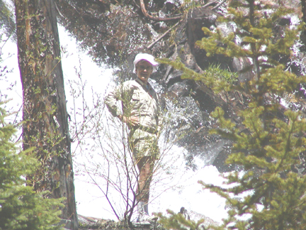
Figure 3. Tumbling Waterfall
|
The first major waterfall. The author is right in the center of the image next to the water.
Figure 4. Tumbling Waterfall close up
|
Steve didn't actually walk all the way over from his position where he took the previous photo - he used his telephoto lens. From where I was standing, I only saw a small part of the falls. In the return direction, we descended on the far side, where for the first time we could see the full extent of the falls (about 100' or 4 times what I could see from here). Note the strong shadows cast by the sun.
We arrived at the proposed campsite at 2:30pm. I'd done it in relays of 20steps, punctuated by pauses of heavy breathing. I thought I'd done OK, and was about to exhort Steve to press on, when I sat down and found I didn't want to get up. I had walked no more than my usual lunch time walk but I was exhausted and even sitting down, couldn't stop hard breathing.
I gave my "You were right and I was wrong" obligation to Steve.
Rather than being determined by the air, the temperature was determined by the combination of heat from the direct sun and the cooling of the intermittant daytime stiff breeze. If I was in the sun I was hot, if in the shade I was cold. I started wondering how the austronauts had regulated their temperature on spacewalks or on the moon - did they have to keep turning in front of the sun? If the daytime stiff breeze was blowing, the sun and breeze cancelled each other and I was at a reasonable temperature, but you had to keep up with the sunblock. In the shade you were cold, or with the breeze - even colder.
The ground was as wet, as I expected, but not muddy. From hiking in Tasmania and the California Sierras, I associate alpine with mud, camping on rocks or mud and having to tie your tent ropes to rocks because of the lack of soil. Here instead, the top 3" of ground cover was spongy moss. In some places the moss was dry and in other places, had water slowly running through it from uphill melting snow. Treading on the wet moss squished out clear water rather than mud. With the low humidity, there was no need to avoid the wet spots - your feet were dry in minutes and without the mud, your feet stayed clean. Below the moss was another 3" of nice soil. If you were anywhere with ground cover (i.e. not in a field of broken rocks), you had 6" of nice clean ground cover to grip your tent pegs. There were plenty of dry soft spongy place for your tent (no sleeping on rocks here). It looked like you could have any amount of rain and still be sleeping on dry ground. Steve had brought plastic tent screws (they look like ice screws), for this sort of ground. Since it was cold at night, Steve had advised I bring a "thermarest" pad, a new gizmo to me.
With the high mountains on both sides, the time of direct sunlight was reduced from 16 to about 10hrs. After sunset behind the ridge, the sky would still be daylight blue, but the air temp would crash to near freezing, and there still would be 3 hrs left before the sky became dark. I put up the tent, and crawled in, breathing hard to recover from the exertion of this herculean effort, and lay down while I figured out what to do next. Just lying down, I was breathing as though I was walking uphill with a pack. What to do? I couldn't lay in the tent for 14hrs like I was on a winter trip - it was still daylight outside. I hoped to get acclimated and be over this phase shortly, certainly in time to enjoy most of the trip. My idea of a good hike was covering the most distance in the time available. At this rate I would be walking about 1/4 of the time and for the rest of it, sitting down freezing cold and puffing.
Steve has a different approach to trips where you aren't acclimated to the altitude. Steve grew up hiking and camping, initially with horses the way it would have been done here 100yrs earlier. He comes for the fishing. He also carries a pack 20lbs heavier than I do, with fishing rods and clothes for the cold, to help him with the idle time, when like it or not, you can't do a whole lot even if you want to.
The lake was about 6-10' deep and clear enough to see the bottom. I don't often see to the bottom of water 6' deep. (Steve says it's 40' deep in the middle out where I couldn't see.) In the lake's tributaries, trout, some 20" long, swam. The water in the tumbling tributaries was crystal clear. I couldn't imagine there being enough organic material for the fish to live on. Apparently they live on surface insects, some aquatic life e.g hellgrammites, worms, and stone fly larvae. I didn't see enough of them to keep a single fish alive, much less all the fish I saw in front of me. The river looked like a wet desert [12] to me.
Lest avid fishermen rush to fish here, leaving a trashed campsite and a fished out lake, Steve wants everyone to know that the nearby Roaring Fork, which runs into Glenwood Springs, and the Frying Pan River are considered some of the country's best fly fishing rivers (and are much easier to get to, being right next to a road). There on any nice day you can see fishermen standing 20-50' apart in the river in their waders. It's a hell of a lot more bother to get to where we were OK? (Just trying to be helpfull now.)
The downwind parts of the lake were covered in a lime green powder, blue spruce pollen according to Steve. Back in North Carolina, for a few weeks in spring the local loblolly pines fill the air with green pollen so thick that on a still day, the air is visibly green, if you have a piece of straight road long enough (about 1 mile) to look along. Cars parked overnight are covered with green powder and many people are incapacitated by their allergies to the pollen. I've started getting the allergies in the last few years. You feel like you have a cold and your eyes and nose run all day. Mardee has allergies from the beginning of spring till the end of summer and for her exercise, goes swimming or winter hiking (anything but outdoors in warm weather).
Steve found some quartz rocks with 2mm tetragonal crystals stuck to the surface, having the appearance of silver metal. I didn't know what to make of them. I couldn't imagine silver just lying about on the ground without the hordes having descended on the place long ago. The crystals were as shiny as fresh chrome. If it was a piece of silver, why was it not surface-oxidised? If it was a mineral like the haematite, why was it so specular? Ordinarily I would have taken the crystals home for futher investigation, but I was filled with lassitude and decided to ignore this problem intruding on my efforts to breathe. On my return home, I found that haematite is trigonal, but galena (PbS, the main ore for Pb) forms large cubic crystals. With Pb being mined everywhere here and not being particularly valuable, I expect it would be easy to find the stuff lying on the ground. But cubic is not tetragonal, so I still don't know what the crystals are.
I raised myself from my hypoxic lethargy, to wash before the sun set behind the mountain. I knew if I was cold now, I'd be even colder with the sun behind the mountain. I was quite looking forward to washing in a clean mountain stream, where thanks to the low humidity, I'd be dry in record time. I took off my volleys and stepped into what I quickly found was melted snow. It was a truly invigorating wash. With the low humidity, no rain and plenty of water for washing, I stayed clean and dry the whole walk. (I don't remember washing much in Tasmania. There, being wet 24x7, staying dry was my major interest.)
Spotting my enthusiastic ablutions, Steve started my Colorado alpine education. You don't camp next to water or next to a trail - you need to be 75 feet away. OK. Also you don't wash in the river, you get water from the river and wash 75 feet away. Hmm. OK.
To make drinkable water, Steve had filter pump. The river water always has to be assumed to have giardia in it, presumably from the beavers if nothing else. Whether the beavers get the giardia from us or we get it from them I don't know [13] . I realised that I shouldn't dip my billy in the river anymore and risk contaminating my food. I washed the billy with filtered water, and heated the billy dry on the stove to kill any giardia cysts. From 1951 through 1990 Steve drank straight from the creeks and streams with never a concern, as had his parents, grandparents and great grandparents before him. There weren't as many beaver back then (even though they were always there). It's the people camping beside, washing, and using the streams as a toilet that prompted the filter (human viruses are going to do you a lot more damage than anything a beaver carries). I remember the days when you could drink from the Kowmung (a large river in the Blue Mts west of Sydney) too, but now I hear people are getting sick from it.
You cook on a propane/butane stove. The fuel, along with the water filter and all the other paraphernalia for the cold, add up weight-wise. Campfires are eschewed here. We were hiking during a fire ban, but in anycase, no-one makes fires. Downed wood in the Sierras (California) was always wet and rotten and there was no wood to burn, so I was already used to hiking without a fire (but didn't really enjoy it). Here downed wood was bone dry and there was wood to burn - it was everywhere. I couldn't understand how 300yrs of wood fuel could accumulate without a major conflagration or two on the way. There was plenty of wood if you wanted it, but no-one wants it. It seems to be a matter of leaving nothing but footsteps and a fire-ring is regarded as gauche. I've learnt from discussions on aus.bushwalking and later with Dave Noble and Mr Bean that burning wood, a renewable resource, doesn't add to the atmospheric CO2 (in the long term), while burning non-renewable fossil fuels (e.g.in stoves) does. However there are many life forms that would like to use the wood before it's sent for renewal and some effort is spent here to educate people that burning wood short-circuits the the 300yr long renewable resource cycle [14] . Since I'd already burned several 100gallons of non-renewable jet fuel to get here, it seems a small price to burn another cupfull of propane and allow the local denizens use of the wood for another 300 years.
There were rodents everywhere, a few pikas (they sit on rocks and call out "pip!") but mainly chipmonks. (On the road out, Steve pointed out the many gophers running across the road, scurrying to their holes at our approach.) Steve slung a rope between two trees and we hung our food on the rope. Steve was expecting varmints (energetic mammals, rodents usually, that can smell food through closed containers and will chew straight through your pack in seconds). You either have your food in your pack beside you, in your hands or in a tree. The local varmints seemed quite friendly and harmless to me. They didn't appear to be the big problem Steve made them out to be, but having already been wrong about other things that day, I hung my food up next to Steve's.
For dinner not only did I have no energy to prepare it, I had no appetite. My body thought I was climbing a hill with a pack, not a time I normally eat [15] . I thought of food or eating it was repulsive and I almost wished the varmints would take it off me, to save me thinking about it for the rest of the trip. I'd brought a carefully weighed amount of food for each meal and I either had to eat it, carry it or chuck it. I can eat anytime normally if I'm at sea level, but I now I was a most reluctant dinner.
During dinner Steve spotted a ruby throated hummingbird. I've only seen hummingbirds in the wild once before, when walking through the Grand Canyon. I had no idea they were at 10,000' in the Rockies.
Leaving only footsteps is all well and good, but once the sun goes down behind the mountain, if you don't have a fire, and you didn't bring parkas and thermal pants, then you have to get into your tent. None of this sitting around the campfire drinking tea business. I'd opted for the lightest pack I could, to optimise the chances of my body lasting the week, and so after dinner, retired to my tent with the sky the color of mid-afternoon. I just beat the mosquitoes for the evening (they're only out at sunrise/set). Steve who was 20lbs better equipped than I, got into his cold outfit and paraded around gleefully calling out the fauna I was missing (e.g. bats, which I like). He wasn't enjoying the mosquitoes, but expected that the bats would get them. I releaved him of his delusion by telling him that bats don't eat mosquitoes (they're too small to be picked up by the sonar and bats don't eat mosquitoes in test situations).
I now had about 3hrs to dark. Being an amateur astronomer, I was hoping to see the stars without the light pollution and the scattering produced by the humidity and pollution of the east coast. In particular, there had been a solar eclipse that day (not visible in north america), so it was the new moon. Mardee and I like trying to see the crescent new moon as early as possible after the astronomical new moon. Mardee usually beats me to the new moon, but I always see the old moon in the morning on the last day possible, as I go to work early in the morning and see it while driving without any competition from Mardee. I always like seeing the old moon in the morning and the new moon about 4 days later in the morning as the cusps of the crescent moon changes orientation by upto 47deg in doing so. (The effect is most pronounced near the equinox.) One orientation will have the cusps pointing up, like a cup or birdbath, while the other one have the moon pointing near horizontal like a headlight.
Seeing the new (or old) moon relies on a good view of the horizon and seeing the moon against darkening sky. Where I was, the crescent moon would be below the moutains behind me. I wasn't going to see the new moon till it was many days old. Even though the sky was beautifully clear for the whole trip, it wasn't till the last night that I even tried going out at night.
Inside the tent it was probably 5-10C, but with enough clothes and sleeping bag to take me well below freezing anywhere else, I was still freezing cold, I lay there wondering what it was like to spend a night at camp IX on Mt Everest and thought about the people who'd perished in there in 1996. One of my friends (in his mid 50's) last year climbed Mt Kilimanjaro, not a technical climb, but the summit is at 19,000'. How did he do it I wondered? (On my return, Mr Bean told me that a 63yr old Japanese woman had done Mt Everest this season.) There was only so much philosophy I could handle and soon enough I went to sleep.
Next morning I awoke nauseated, with a headache and no energy. Clearly by my breathing I had not accumulated a whole lot of altitude adaption overnight. No wonder asthmatics get distressed when they can't breathe. Not only that, my eyes were stinging and watering - I was allergic to the Blue Spruce pollen. It hadn't occured to me to bring allergy medication (or ask Steve, he had some in his kit and which I didn't know about till after my return). I don't normally eat breakfast, but on a hike I thought I should. I ate 250g of muesli, which was no fun at all. Under the circumstances it was the most difficult thing I did all day (dinner was the next most difficult). Dehydration is supposed to be a problem at altitude. I wasn't at all thirsty and just decided that if I peed occassionally and it was a suitable colour, I was probably doing OK. Steve decided that we should take an altitude adaption hike, upto our next campsite and back, without packs. In the afternoon we would fish.
We continued up the parabolic valley, out of the trees into the the clear sun, sometimes walking on broken rocks and sometimes on moss. Wherease before the snow was only in the shade, here we came to large patches of snow in the open.
Figure 5. Sitting in the snow

|
I wouldn't have done this if I'd been anywhere else. With the sun and the low humidity, I could guarantee I'd be dry in minutes after walking away. Note the small lake at the RHS of the photo dependant on the snow drift.
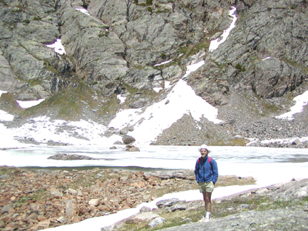
Light reflected from the grey rocks on the mountain sides was almost as bright as snow and I kept applying sunblock. I remembered David Breashears ("High Exposure") describing the dazzling heat and light while climbing Mt Everest, even though the air temperature was well below zero. The next campsite was a pretty spot, next to a lake and below a several 100' drop of water from many rivers bouncing out of the lip of a cirque a mile or so up the valley.
Figure 6. A preliminary recy to Camp II
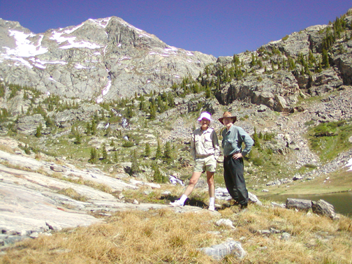
|
Author on viewer's left, photographer on right. One lake is behind and on the RHS of the picture. Another lake immediately is below it (out of picture). (We're at least 75' from the water, by the way.) A stream of water is coming down the mountain in the left mid background (in line with author's right shin) into the lake. Our trip took us to the lakes feeding this stream of water. Note the blue sky. It really looked like this. The ground alternately has wet and dry spots depending on the ground above it e.g. patches of snow or rocks sitting on beds of ice.
A clean ridge ascended from us to the main ridge line above at 13,000'. At sea level I would have been up and down it in a flash. I made a feint of setting off, to Steve's amusement. "Go ahead, I'll watch from here. If you get into trouble, just wave and I'll hike out and tell the rangers where you are."
With Steve and I both having PhDs in biochemistry, I tried to figure out the biochemistry of the altitude problem. I wondered what I could do to make any subsequent trip easier. At least understanding it would seem a step ahead of the impotence I felt on having it. I didn't find out much about the problem till I returned home and started looking on the internet. The real problem I was having (headaches, nausea) turned out to be mild oedema [16] . I don't remember breathing hard at this altitude 20yrs earlier. Presumably that's the primary cause.
We returned to Camp I when Steve declared it was fishing time. I'd never fished before. Out came the flies and Steve showed me what to do. One of Mardee's friends walked for several weeks in Alaska feeding himself mainly on the fish he'd caught. Apparently hiking and living on fish is practical in some places. Steve regaled me with stories of fishing on his other Colorado trips while I was dealing with learning to cast in a stiff breeze, with a headache, nausea, allergies and lassitude. Nothing was going to be fun while I felt like this, especially since both alternatives of sitting down and doing nothing or fishing looked equally bad. I decided to see if I could catch a fish to tell Mardee's friend. Soon enough Steve had caught one of the bigger fish (11"). Steve cooked it up and I sampled it without much joy, and I ate my dehydes with little alacrity. The smell of the cooked fish permeated the camp and would seem to negate our efforts hanging food in trees so that animals wouldn't know that humans had arrived with food.
The next morning, I still was suffering from the altitude, decided to skip breakfast, and we retaced our previous day's steps back to the lake we'd visited the previous day. There we setup camp, again in the middle of the afternoon.
Camping away from water was new to me, and we camped several 100' up the hill from the lake, after filling our water bottles. From our campsite way above the treeline, we had a great view in all directions, including the lake below us (photo above) and south down the valley for miles.
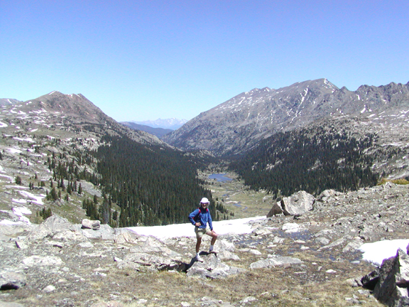
Figure 7. Looking south east to the sides of the parabolic valley from Camp II
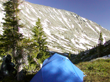
|
Note: the sun is just setting behind the mountain to the west (to the right of the photo).
Figure 8. Looking south back down the valley from Camp II
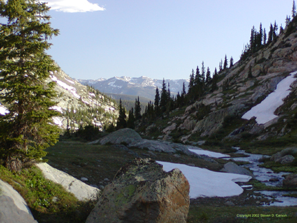
|
This photo is pointing a little to the right of the previous photo.
There not being a whole lot to do, we amused ourselves watching a family of marmots who lived at the lake edge. Marmots are the size of a beaver but instead of being grey with a flat tail for packing mud and making dam walls, the marmot is a golden red with a long fluffy tail, which it swishes in a circle as it runs. The marmots easily lept a river too wide for me to jump across, and scrurried along the snow with ease. One of them visited us and didn't seem to be afraid of people.
Figure 9. Friendly marmot at Camp II
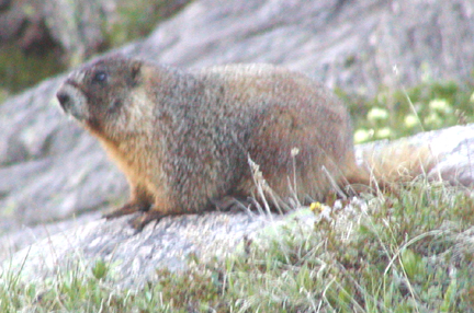
|
I had wondered what they ate, there not being a lot of biomass at these altitudes. Then I saw the marmot cropping the moss like a cow on pasture. If that's what they ate, then there was plenty of food and I wondered why there weren't thousands of marmots.
We were on a mossy pad below a field of broken rocks out of which water trickled at a steady pace. Depending where you stood, the moss was either soaking wet or bone dry (but looked the same, you had to step onto it to find out - it's not like one lot was green and the other brown). Steve explained that not only did the snow hold water to feed the streams throughout summer, but the rock fields held water that froze in the winter and which only melted slowly in the summer, because it was shaded by the rocks. The rock fields instead of being barren and dry were places for storage of water (as ice).
I had no interest in eating food, and now found myself fantasizing about the salty taste of tomato soup and french onion soup, things I don't normally eat. I wondered if I was short on salt. I'd never been short on salt before even with extended vigorous exercise in the heat of Sydney summer when I was younger. I wasn't even sweating here. It would have been hard with the low humidity for any water to form on your skin, but my back where the Tompack rested never got damp and neither did under my shoulder straps. I hadn't eaten any breakfast or lunch, but forced myself to eat my dehydes for dinner.
I was cold and retired to my tent after the sun set behind the mountain, while Steve wandered around doing things that normal people do in the afternoon. That night I thought about bears and mountain lions. A mountain lion could pad quietly upto your tent without you even knowing about it. No wonder the early people here had shot them out to extinction (or near extinction, I wasn't sure, and wondered if the last few were in this valley).
The next day I awoke to find the water that had been running out of the rock field above us had turned to ice and the lake below us partially frozen. We left our tents and set off with day packs upto the pass at 11,800'. I had a headache and was still nauseated. Is this what chemotherapy is like? How do people survive 6 months of this? I had decided the effects of eating were much worse than any possible effects of not eating. For breakfast I had enough coffee to supply me with water for the day. We ascended beside the very pretty multiple streams tumbling down the steep slope from above us.
The small lakes as we ascended were mostly frozen over.
Figure 10. Lake Feeding stream to Camp II
|
We were walking mostly in snow and the trail, if ever you found it, quickly disappeard beneath drifts. The light was blinding and I had to squint. I now found the only thing that Steve had forgotten to mention in his list - sunglasses. Steve always carries clip-on sunglasses and doesn't regard them as part of his hiking equipment. I was staggering around in the blinding snow, while Steve was wearing jet black clip-ons that looked like arc-welding glasses.
Water trickled out from underneath most of the snow drifts and Steve pointed out that the snow was not solid to the ground, but at this time of year was snow bridges. Mostly the snow supported us, but Steve, being heavier, sank upto his waist, on one leg, in occasional collapses. I never went much below my knees, and carefully extricated myself each time not wishing to leave a volley behind and have to walk home short a sandshoe. I imagined climbing out of a deep collapse would be like recovering from falling through ice on a lake - there'd be no edge to grab to help you climb out, so we avoided snow over our heads.
I still was feeling the effects of altitude, and within sight of the pass at 11,800', the nausea was steadily increasing. The breakfast coffee and most of last night's dinner were still in my stomach. I told Steve that I'd had a headache since the first morning and I wasn't feeling my usual cheerfull self at the moment. I tried ignoring the symptoms, till it dawned on me that the waves rushing through my body were familiar symptoms from another area of my life. They signalled the immenent arrival of my first chunder in Colorado. Picking a convenient spot (75' from water), I did the two finger salute and disgorged a billabong of coffee from the morning and dehydes from the previous evening. Since my last big chunder several years ago, I've started wearing glasses, and the inside surfaces of the lenses were covered with opaque splotches from the backsplash (the things I didn't learn about when I was younger).
Having just a few minutes before found out about my multiday headache, Steve was most concerned at this new development. For what reason I could not imagine, as I now felt better than I had for days. Steve was worried that I was developing cerebral oedema, one of the outcomes of altitude sickness, and that I would shortly go into convulsions. (Cerebral odema can be fatal and you only have a day or so warning of its onset to execute the only known cure, of getting the person off the mountain to lower altitude). I had no such concerns as my body was now filled with the normal post-chunder good feelings of relief. Steve asked me for the square root of 2, which I did to 6 places, but slowly and requiring 3 attempts and the last two places were from the value of pi. I thought Steve was going to call a timeout on me on the first try and tell me to start walking downhill straight away. I could have calculated it in my head faster at sealevel. If we'd found ourselves in a snow storm or injured, I wasn't in great condition to think quickly or clearly. Clearly I was relying on Steve a lot here.
Last time I'd chundered in the bush, I was climbing out of Claustral when I was coming down with the 'flu. I shouldn't have eaten anything for lunch, but relented when Dick Hain offered me some of his mother's fruit cake, which he knew I liked. I threw it up on the climb out. I didn't bother to tell Dick and Pete, taking the philosophical stand that if you chunder and no-one is there to see it, it doesn't count. In the time since I've left Australia, it appears that there are now protocols for chundering in the bush, in particular that you don't do it on the trail. We were waiting in the parking lot at top of the climb and a highly incensed person in a party behind us demanded to know if one of us had chundered on the trail. Knowing it wasn't either of them, Pete and Dick turned to me grinning. This was a person severly lacking in humour and understanding of biodegradability to boot. I took the Ronald Reagan position, that I couldn't recall seeing anyone chundering on the way up. I later found that I had a temperature and started feeling better after taking some aspirin to bring down my temperature.
This event at 11,800' turned out to be the turning point in the trip for me. I found with no food in my stomach, there was no nausea. It was as simple as that. It wasn't all that difficult a decision since I didn't have any appetite. My energy level wasn't great, so I continuing to not eat wasn't going to make it any worse.
At the pass where the wind could only be compared with Windy Saddle in the Reserve (Cradle Mountain National Park, Tasmania) near Mt Ossa (possibly between the Pelions). The snow was bright and I squinted to look anywhere. I sat in the lee of a large rock and looked out onto a meandering river in a long flat valley 3000' below us and to the ridge lines 2000 feet above us on both sides.
Figure 11. Looking North over Cross Creek, from the Pass at 11,800'
|
This photo is taken in the same direction as the panorama at the top of the first page.
On the left ahead of us, on the sloping treeless side of a mountain (mid background on previous photo but not really visible), we saw the streak of tailings coming out of a dark spot marking a mine entrance. The mine would have been 3000' above water in the absence of snow. There were no trees nearby wood to cook, or for mine timbers and no shelter, shade or flat land anywhere. The place would have been weeks away from any supplies 150yrs ago. Someone had spent at least several months working this mine.
I contrasted this mine, that would have been days or weeks from anywhere, with the depth of exploration of Australia even till recently. Mt Tom Price, the biggest pile of iron ore in the world, lay undiscovered till 1962 when a 71yr old american, Tom Price, flying over it in his private plane, looked out his window and observed "why, that looks to be a whole mountain made out of iron ore". This was the version of the story I heard back then. The official version of the story looks a little different, but the original story is still recognisable. Here's some info on the iron resources in WA (http://www.mineralswa.asn.au/~cmeiron/page10.html, bad hostname Dec 2003). (Australia exports 98% of its iron ore). I know the NW of Australia isn't an easy place to explore, but Colorado 150yrs ago was no cakewalk either. I know that iron ore cannot be mined economically by an individual, and any prospector 150yrs ago in the Kimberleys would have ignored Mt. Tom Price, but I was impressed to see this mine in Colorado, that even today is a long way from anywhere.
To the right (previous photo) was the back of the Mt of the Holy Cross (14,006', 4269m). Before I'd left for the trip, I'd noticed this name on the maps, and couldn't imagine how such a name could get attached to a mountain. Since then I'd quite forgotten that the mountain existed. Steve explained that on the other side of the mountain facing away from us was a pattern of rocks and clefts that held snow in the shade for nearly all year and which made a (christian type) cross the height of the whole mountain side. Due to a landslide, the one arm of the cross is not so well defined now. Suddenly I remembered an exhibit in the Smithsonian Museums in Washington DC, of art that 150 yrs ago, had popularised the american west and had helped the move the people from the big cities in the east to the then unpopulated frontier.
One of the artists celebrated was Albert Bierstadt, whose dramatic paintings were evocative (if not exactly representative) of western scenery (heres a list of Bierstadt's paintings). His style makes Yosemite Valley look like the home of the Olympic gods. For anyone who knows what Halfdome looks like, here's Bierstadt's version of it. Overdone or not, Bierstadt's art helped propel millions of people west. Presumably those people arriving in the west, after comparing notes, are responsible for the truth in advertising laws we have now. Whether Bierstadt intended to deceive I don't know. We do know he was paid more money for his paintings of glorious fabled scenery than were the people who painted cow sheds. He was befriended by wealthy patrons, was wealthy and was a success in his lifetime, a goal not achieved by most artists till they're dead and the investors know that the production run is finished.
The painting I'd remembered was of a white (presumably snow) cross on the side of a mountain. Not having heard of this mountain and with no commentary besides the title of the painting, and in the company of the other "enhanced" paintings by Bierstadt, I didn't even know if the mountain was real. 5 years later, I was at the back of this very mountain and it was real. A search of the internet would indicate that the painting probably wasn't by Bierstadt, but possibly was a small copy of a large painting by Howard Streight called Cross on the Mountain. Here's a photo of the cross and another photo of the cross. In the painting I'd seen, the mountain was about 10miles away and the cross was much thicker than shown in the photos. Possibly the cross had been "enhanced" for popular consumption, or maybe the snow had been heavier that year. The mountain was a site of pilgrimages for Christians for many years, although not officially blessed by any of the Christian churches.
Steve's target for the day was a lake about a mile away, a target high on his priorities after a previous failure From where we were, it was solid snow wading and the target lake was frozen over and surrounded by snow. It didn't look like a quick or fun trip and Steve decided to forget it this time too.
At sea level, the return trip to the car, even with a pack, would have been only an active afternoon. From here it was going to be two camps. I was appalled the debilitation I felt from the altitude. Steve's comment was that a week was either too short or too long for a trip at this altitude. There are 55 peaks over 14,000' in Colorado. While some of them are techical climbs, many are just a matter of running up some ridge and hoping along the backbone of ridges from one to another, something that isn't too difficult if you're acclimated. You do have to know what to do if you're caught in a snow storm in summer, but it's not like you have to do any major scrub bashing. Steve remarked that on one trip, while labouring un-acclimated with a pack, he'd meet a group of people doing a peak run Three Peaks style. (Here's a 3-D image of the Sydney Three Peaks trip, which can be found at the bottom of Dave Noble's bushwalking page.)
On the way back to the camp, we saw an unidentified raptor wheeling overhead, presumably checking for australians with cerebral oedema (the tail feathers matched those of a juvenile bald eagle in one of Steve's books when we got back). Bald eagles are endangered (their numbers having dropped into the 100's in the '60's, due to the effects of DDT), as well as the animal the US uses as symbol. The US is suddenly very protective of them and possession of a bald eagle feather is presumptive evidence that you've killed one and you'll be put in jail. Even bald eagle feathers are protected.
Steve was out ahead when he ran across a pair of white ptarmigan. The male had ran out from behind a rock and Steve realised that he was acting as decoy to lure us away from the nest and that the female must be close at hand. I followed the male to identify it and Steve spotted the female in a few seconds. It was sitting quietly in front of him and hadn't moved. Steve had almost trodden on her.
Figure 12. Female ptarmigan
|
Steve managed to extract his camera from his pack and take this photo without spooking the bird.
On returning to camp, I could only think about tomato soup and french onion soup, the nearest instances of which were two days away. If I was after salt, then I wasn't having any vegemite cravings. I had brought some miso soup and I enjoyed that for dinner, but I didn't try anything else. I sat on a rock and watched the marmots playing several 100' below. A marmot started across a snow field below me, and suddenly stopped in the middle. With a raptor in the area, this wasn't a great spot for a golden red marmot to be sitting. He didn't move for minutes and I couldn't figure out why he would stay there, exposed for so long. Then I realised he might be worried about me wanting him for dinner. If it was the same fellow who'd visited our campsite the evening before, I didn't expect he'd care about us at all. I waved to him to test my theory and he shot off across the snow into the grey rocks. A hypoxic australia at 400m range looks more threatening than a raptor to a marmot.
It was another cold night and next morning I didn't seem to be any more acclimated than the day I'd arrived. Even in the sun you had to be dressed up.
Figure 13. Hanging around Camp II in the morning
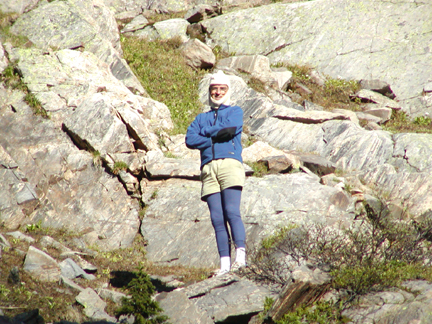
|
Steve's face and back of his hands were vivid red. His eyes, behind the shadow of his sunglasses were white - he looked like an reverse raccoon (or see more pictures of raccoons). Despite Steve's lectures about the skin blistering sun, he hadn't brought sunblock. He didn't think he'd need it. He gladly used mine. I'm glad I did what he said and used sunblock, rather than what he did.
We returned to Camp I and although I didn't feel great, I felt at least better than previously. My headache wasn't so bad and not eating had cured my nausea. I wasn't breathing so hard but I didn't have much energy. I wasn't suffering for lack of food (my ribs weren't sticking out). Steve, working on ways to lighten his pack, tried to palm off his excess food in the guise of being helpful. I countered with an offer of 5 days of muesli, fig bars, dates and 4 dehyde dinners. It was a tough sell and Steve wasn't having any of it. I tried one of Steve's power bars, a slab of what looked like yellow extruded plastic encased in chocolate (not one of my favourite foods). It had as many calories as one of my dehyde dinners, but without the the additional trouble of cooking. Maybe I should have been eating these all along. It didn't taste good and I regretted eating it with the sensitive state of my digestive system. I found the most important ingredients listed were branched chain amino acids, something I hadn't worried about before. There was no fibre. If you depended on them for a week, you'd be totally blocked up, a more gruesome fate than any AMS.
At Camp I, I looked up and saw the now 5 day old crescent moon against the beautiful deep blue Colorado sky. The remnants of the gathering of the visible planets the previous month (14 May 2002), were still apparent, with the moon next to venus, and with jupiter now closer to the sun. The moon moves through it's diameter in an hour against the fixed stars, and with venus as a reference point, I could track the movement of the moon with respect to venus till they set, two hours later.
I still had no interest in being outside the tent after the sun set behind the mountain, but my brain must have been working better with more oxygen at the lower altitude, for I decided that I should warm up before getting into bed by walking up and down a slope till I got warm. I did this for about 10mins. Steve warned me not to get to the stage where I sweated (fat chance, it was too cold) and then commented when I was finished that moutaineering books recommend you do exactly that before getting into your sleeping bag. This time I slept toasty warm without any of the clothes I'd worn the previous nights. I don't know whether it was the warm up, or I was getting acclimated. I did wake up in the night, and peaked out at the stars, which were beautiful. The bright stars looked like jupiter at sea level on the polluted east coast. I didn't go out for a better look; some other trip maybe.
We got to Steve's car about midday and although it was the same brilliant sun, inside the car it was only 57deg. It must have been cold the night before at the car. When we got back to Eagle, I could tell I was still at altitude, so I pre-emptively consumed 2 beers to ward off any of the effects of dehydration that I'd accumulated during the week. I managed to eat dinner (including french onion soup), and regained my appetite slowly over the next few days.
On the way back along I-70 to Denver the next morning, we passed the sculpted saucer house at Genesee Valley, used in Woody Allen's 1974 movie "Sleeper". Here's a bit of a write up about the house (http://www.citymtnviews.com/attractions.asp, link dead Aug 2003) and (http://www.citymtnviews.com/neighborhoods.asp, link dead Aug 2003) and a photo Although construction began in 1963, the house wasn't lived in till 2000.
I also noticed a bike path parallel to the freeway, but several 100yrd from it. It must have been 20-30miles long. There was one bunch of several 100 riders on it, presumably in a race and other people zipping down the hill, getting a free ride from gravity. You can start from the Eisenhower Tunnel at the continental divide and get a gravity assisted ride heading east or west. I noticed a few hard core people riding up the path, not down it.
Steve dropped me at the mile high airport in Denver and began his 8hr drive home, while I sat in the airport reading about the fires that had been consuming the state while we were hiking.
Because of the altitude effects, the trip had felt like a week with mononucleosis/glandular fever [17], in a coldroom, with a stiff breeze. It was 3 months before I started drinking much coffee again.
[1] "How the Shaman Stole the Moon", William H Calvin, 1991, Bantam, p117. This book shows how it might have been possible for pretechnical societies to understand astronomy, eclipses and seasons in a relatively short time. For instance a priest standing in the Acropolis with a clear view of the horizon (sea, cloudless skies), at sunset on the full moon, would first observe the direction of his shadow and then the direction of moonrise. If they aligned, you would have an eclipse. The moon's orbit is inclined at 9 deg to the ecliptic. An eclipse will occur at if the moon is within (about) 2 deg of the ecliptic. With the diameter of the moon being 0.5deg, it is possible to determine by eye, whether an eclipse will occur.
[2] "Deserts", Seymour Simon, 1990, William Morrow, a children's book from the local library that my son is reading.
[3] About 2 months later, I was in Maine (NE corner of USA), where the treeline is at 3,000'
[4] Americans like skiing among the trees, see this article about the death of Sonny Bono and Michael Kennedy and another article, which may account for the expression "white men can't ski" :-)
[5] New York Times, Obituaries, p25 28 Jul 2002.
[6] In the US a National Forest is a piece of Wilderness with less restrictions than a park. You can camp pretty much wherever you want, whereas in National Parks you can be quite restricted. The wilderness quality is often as good as a National Park. Our trip was in a National Forest designated as a wilderness area, which places extra restictions on its use.
People can hunt in Nation Forests (and some National Parks) - in season. Hunting season used to start on the same day each year for all fauna, resulting in 250,000 hunters in the woods on opening day, all shooting at each other (a hunter in a bright orange jacket and cap is easy to confuse with a deer). I remember growing up in Australia, on the first day of the US hunting season, when the newsreader on TV would announce with a half smile, the number of hunters that had died that day. My brother would make an aside "a spokesman for the ducks reports that casualties are light". Of course this couldn't go on forever, or there'd be no-one left to do the hunting, so now hunting season starts on different days for different animals and for different methods (bows, guns...) and the carnage amongst hunters has thankfully dropped.
Unfortunately Pb is still used for bullets (and for fishing sinkers). Instead of blasting hundreds of pounds of lead to the environment each year, you'd think by now that hunters would have found more ecologically friendly ways of killing wild animals. The US DoD at least has taken a step in that direction, replacing the ozone depleting R12 freon in the cooling for its nuclear warheads with R134a thus ensuring that the country's entire missile defense system is ozone layer friendly (can't find a link for this, the changeover occured in the early 1990s).
Steve grew up hunting and still does. Steve knows a lot more about the native animals than most of the tree huggers who I normally hang out with.
In Australia, names sounding like "National Forest" are used for pieces of land turned over to commercial growth of non-native trees. In the US, these commercial forests are on private (company owned or leased) land which the company controls (i.e. you aren't allowed in there, even to save ancient redwood trees).
[7] Amazingly, I couldn't find any websites showing photos of downtown Eagle. The town website shows only the new county offices, something that everyone on the web really wants to see, of course. The Chamber of Commerce however is a little more on the ball and has some history of the area and a photo showing the vegetation found in the arid climate.
[8] "Over the Edge: Death in the Grand Canyon" Ghiglieri and Myers, ISBN 097009731, Puma Press 2001.
[9] I don't have this reference anymore. It was in some article describing the distribution of coal in the world. I probably read it in "Science" or "Nature" at least 15-20yrs ago.
Steve pointed out that in the last 20yrs, the western world has realised that China has lots of coal too.
[10] This as, any high school chemistry student will tell you, is the "water gas" reaction, used in the gasworks at Meadowbank, to produce gas for homes until Sydney changed to natural gas. In this process, steam is blown through a bed of coke that has been raised to high temperature by burning in air. The water gas reaction is C + H2O -> CO + H2. The reaction is endothermic and will eventually put out the coal mine fire (or extinguish the fire in the coke bed). Since the fires have done several billion$ in damage, it occurs to me that you can buy a lot of water for $billion and they should have persisted with water to put out the coal mine fire. You would probably not want to be near the coal mine vents with the CO coming out, but otherwise it would seem a reasonable scheme to me. Since the "water gas" reaction is endothermic, you eventually have to heat up the coke again by blowing air over it. This is the exothermic "producer gas" reaction; O2 + 2C -> 2CO. The gas produced is of lower calorific value, since it is mostly N2.
[11] Nearly all houses in the US are wood frame (rather than brick) with sheet rock (rather than plaster) walls. Cherrybrook in Sydney (I'm told) is built this way. Due to minimal (or no) town planning and zoning, in the US, this year's houses of the well-to-do become the slums of 30-50yrs time. In Sydney I find on my return that just about everywhere in Sydney is being continually upgraded because people can know that their neighbourhood will not change dramatically in their lifetime. However in the US, neighbourhoods change dramatically on short time scales and no-one expects their expensive house in a fancy neighbourhood will be the same in 25yrs. Rather than accumulating value with generations, a house can be depreciated to $0 in 50years. This does wonders for the GNP, realestate agents and builders, but personal savings suffer, each person having to be responsible for building a house in their lifetime.
[12] The concept of a desert as being a dry place is new. The original meaning was from the French word, desert (pronounced like the Eng. dessert) which was used in the sense of deserted or barren. The current meaning of desert, an area with <10"/pa rain, came after the exploration of the arid american west in the 19th century.
Part of Acadia National Park in Maine (NE of USA) is Mt. Desert Is., an island of deserted mountains (named by Champlain) that have been cleaned of topsoil by the recent glaciers. (You can buy calendars of Acadia Park anywhere in USA, and there are 100's of webpages offering lodging in the area of the park, but do you think I could find on the web a nice photo of the treeless pink granite hills of Mt Desert Is web? noooo.)
"Roadside Geology of Maine", D.W. Caldwell, p78. Mountain Press, Missoula, Montana, 1998. ISBN 0-87842-375-3.
The Great Australian Bight has no rivers or upwellings to supply nutrients and is described as a "wet desert". The small amount of fish there grow slowly and are being rapidly depleted by overfishing.
"The Future Eaters", Tim Flannery, Ch9. Reed New Holland, 1994, ISBN 1-87633-421-5
[13] I've heard that malaria is a disease of mosquitoes in which humans are the vector.
[14] The stages of breakdown and the occupants of a pine tree starting its recycling, are
- declining (lower branches dead) - black bears
- dead (all braches dead) - racoons, wood ducks
- loose bark - bats, scorpions, flying squirrels
- clean (no branches, just a bare trunk) - white owls, squirrels, woodpeckers
- broken (trunk disintegrating with top gone, but still standing) - owls, hawks, fishers
- decomposed (only bottom half of trunk remains) - chickadees, wrens
- root ball - salamanders
[15] I checked it out back at sea level. Puffing up a hill I wasn't hungry at all. I had to sit down a bit before I wanted to eat.
[16] Clearly, getting more haemoglobin would take a month or so. DPG, the haemoglobin modulator should change in minutes. The other possibility was that the muscles were dumping lactic acid into the blood for the liver to process. I couldn't see this as a problem as I my liver can process lactic acid to the level of strenuous activity and it should be able to clean up whatever small amount of lactic acid I was producing from just walking around. I found it hard to believe I was in this much distress with O2 down 30% when at sea level I could do strenuous activity, which I expected would bring my blood O2 level down more than that. I remembered that the south american natives chewed coca leaves to aid carrying heavy loads at high altitude in the Andes, but then the cocaine was more to help with the pain of the load than the attitude. (see this paper by the UN for some details.)
On my return to North Carolina I looked on the internet for preventive measures - I didn't want to go through this again for any future 1 week trips if there was anything I could do at sea level. Coming off altitude this time was more like recovering from being seasick, it just slowly went away. Increased aerobic conditioning must help I thought. The webpages describing preparation for altitude, for people going to Macchu Picchu in Peru or to Kilimanjaro, or Iron man competitors, or for runners competing in the Pike's Peak marathon just tell you to go there 3 weeks ahead of time. Most of the symptoms of altitude (acute mountain sickness, AMS) such as headaches and nausea are due to the odema (water retention) caused by low [O2] and are not directly a matter of cardiovascular condition (e.g. see Adventure Dynamics website). While the people climbing Kilimanjaro may be a pack of cut-lunchies, anyone contemplating a marathon at altitude presumably is in peak cardiovascular condition already. Presumably my problem was odema and not a lack of cardiovascular conditioning, as I had thought while I was on the trip. I've heard that your brains shrink as you get older, in which case I shouldn't be suseptible to AMS anymore (I guess I could still get the pulmonary odema). Apparently most of the symptoms of AMS subside in 3-4days. One solution is the prescription drug diamox, a diuretic which also makes you breath faster (you need to increase your water intake correspondingly). Apparently eating lots of carbohydrates (> 70% of your calories) and drinking lots of water is essential to handle AMS (even if it makes you throw up).
It would seem there isn't much preparation you can do at sea level. The only thing available for people at sea level is an airtight tent that allows you to sleep at 10,000'. I don't know why people can't sleep at sea level breathing a mixture of 87% N2 and 13% O2 instead of normal air (78% N2 and 20% O2). Presumably you could buy cylinders of gas and put them next to your bed and wear a high altitude face mask for the night. I'm sure it would be cheaper than $10k. I then realised that by sleeping with a bedsheet over my face, I would breathing air with reduced O2. I found that I didn't like having my face covered and couldn't go to sleep. Presumably the high [CO2] raises alarms in your body, which attemps to get you to better air. Maybe next time I'll just try diamox.
[17] During my PhD I had glandular fever/mononucleosis, which put me out of action for a year, I lost about 15% of my body weight and had to deregister for a term. I'd had to titrate my activities, choosing the order I did everything e.g. so that I only climbed a total of one set of stairs in a day.